

Kenya’s Notable Hills
Kenya’s Notable Hills : Kenya is home to several prominent hills and mountain ranges. Here are some of the well-known hills found in Kenya:
Mount Kenya
While not a hill per se, Mount Kenya is the highest mountain in Kenya and the second-highest peak in Africa, after Mount Kilimanjaro. It is a stratovolcano and a UNESCO World Heritage Site. Mount Kenya is known for its scenic beauty, diverse flora and fauna, and challenging climbing routes.
Mount Kenya is the highest mountain in Kenya and the second-highest peak in Africa, after Mount Kilimanjaro. It is a stratovolcano that is located in central Kenya, northeast of the capital city Nairobi. Here are some key details about Mount Kenya:
Elevation: Mount Kenya reaches a height of 5,199 meters (17,057 feet) above sea level at its highest point, called Batian.
Peaks: Mount Kenya has three main peaks—Batian, Nelion, and Point Lenana. Batian is the highest peak and is considered technically challenging, requiring mountaineering skills and experience. Nelion is slightly lower than Batian, and Point Lenana is the third-highest peak but is the most accessible for hikers.
Climbing Routes: There are several climbing routes on Mount Kenya, catering to different skill levels. The most popular routes include the Naro Moru Route, Sirimon Route, Chogoria Route, and Burguret/Teleki Valley Route. Each route offers unique experiences and varying levels of difficulty.
Vegetation: Mount Kenya features distinct vegetation zones as you ascend. The lower slopes are covered with dense forests of bamboo and montane forest, giving way to heathland and moorland at higher elevations. Above the treeline, the landscape becomes rocky and alpine, with scattered plants and lichens.
Wildlife: Mount Kenya is home to a variety of wildlife, including elephants, buffaloes, monkeys, hyraxes, and various bird species. The surrounding Mount Kenya National Park provides protection to these animals and offers opportunities for wildlife viewing.
Cultural Significance: Mount Kenya holds great cultural and spiritual significance for several Kenyan communities, including the Kikuyu, Embu, and Meru people. It is considered a sacred mountain and is associated with various folklore and traditions.
Climbing Mount Kenya requires proper planning, physical fitness, and adequate acclimatization due to its high altitude. It is recommended to undertake the climb with the assistance of experienced guides and porters. The mountain’s breath taking beauty, diverse ecosystems, and challenging peaks make it a popular destination for mountaineers and nature enthusiasts from around the world.
Ngong Hills
Ngong Hills is a range of hills located southwest of Nairobi, the capital city of Kenya. Ngong Hills is situated in the Great Rift Valley, approximately 22 kilometers (14 miles) from Nairobi. It is easily accessible and has become a popular destination for day trips and outdoor activities for both locals and tourists.
The Ngong Hills consist of a series of peaks and ridges that stretch across a distance of about 12 kilometers (7.5 miles). The hills are characterized by rolling green slopes, scattered trees, and rocky outcrops. The highest peak, called Kona Baridi, reaches an elevation of around 2,460 meters (8,070 feet) above sea level.
Ngong Hills offers stunning panoramic views of the surrounding landscapes. On a clear day, visitors can enjoy breath-taking vistas of Nairobi, the Great Rift Valley, and the Maasai Mara plains. The hills are particularly picturesque during sunrise and sunset, creating a dramatic play of light and shadows.
Ngong Hills is a popular kenya safari spot for outdoor enthusiasts and nature lovers. The hills provide opportunities for hiking, trail running, picnicking, and photography. There are several designated trails of varying lengths and difficulties, allowing visitors to choose the route that suits their preferences and fitness levels.
The Ngong Hills hold cultural significance for the Maasai people, who are native to the area. The Maasai have a long-standing connection with the hills and consider them sacred. Visitors may encounter Maasai herders grazing their livestock on the hillsides, showcasing their traditional way of life. The Ngong Hills gained international fame through the autobiographical novel “Out of Africa” by Danish author Karen Blixen (also known as Isak Dinesen). The book, later adapted into an Academy Award-winning film, depicted Blixen’s experiences living on a coffee plantation at the foot of Ngong Hills.
Ngong Hills offers a serene escape from the bustling city life of Nairobi, providing visitors with an opportunity to immerse themselves in nature, enjoy outdoor activities, and appreciate the scenic beauty of the region.
Hells Gate
Hells Gate National Park, located in the Rift Valley, has distinctive cliffs, rock formations, and volcanic plugs. While it is not specifically a hill, it features several hilly areas and is known for its beautiful scenery and abundant wildlife.
Menengai Crater
The Menengai Crater is an impressive volcanic caldera located near the town of Nakuru in Kenya’s Great Rift Valley. The Menengai Crater was formed by volcanic activity approximately 500,000 years ago. It is considered a dormant volcano, which means it has not erupted for thousands of years. The crater spans an area of about 90 square kilometers (35 square miles) and reaches a depth of around 485 meters (1,591 feet).
The Menengai Crater is situated about 10 kilometers (6.2 miles) north of Nakuru town, making it easily accessible for visitors. Nakuru is a popular Kenya safari tourist destination known for its national park, Lake Nakuru, which is famous for its flamingo populations. The Menengai Crater offers breath taking views of the surrounding landscape. From the rim of the crater, visitors can enjoy panoramic vistas of the Rift Valley, Lake Nakuru, and the surrounding hills. The crater itself is covered with lush vegetation and dense forests, providing a picturesque setting.
The Menengai Crater provides opportunities for hiking and exploration. There are several trails that allow visitors to hike to the rim of the crater and explore its interior. Hiking through the forests and along the crater rim provides a chance to appreciate the unique flora and fauna of the area. The Menengai Crater is also of significant geothermal importance. The area surrounding the crater is known for its geothermal energy potential, and there are ongoing efforts to harness this renewable energy source for electricity generation. Geothermal power plants have been established near the crater to utilize the natural heat stored within the Earth’s crust.
The Menengai Crater holds cultural and historical significance for the local communities. The crater and its surroundings are home to several ethnic groups, including the Kikuyu, Tugen, and Nandi people. It is considered a sacred place with cultural and spiritual importance.
The Menengai Crater offers a unique natural and cultural experience for visitors. Its stunning landscapes, hiking opportunities, and geothermal significance make it an intriguing destination within Kenya’s Great Rift Valley.
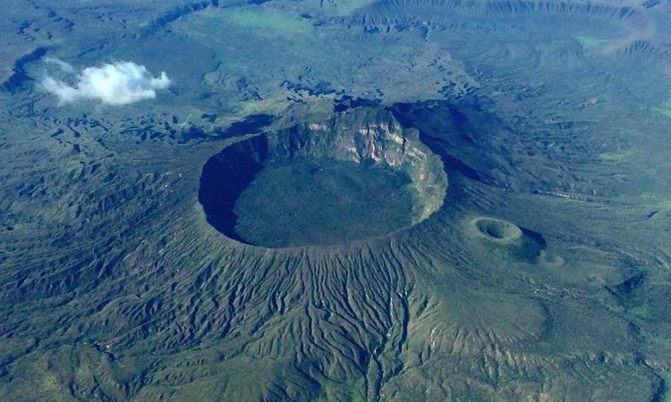
Longonot Mountain
Mount Longonot is a stratovolcano located in the Great Rift Valley. It is known for its circular caldera and offers hiking opportunities to reach its rim. The summit provides a breath taking view of the Rift Valley and Lake Naivasha.
Longonot Mountain, also known as Mount Longonot, is a stratovolcano located in the Great Rift Valley of Kenya. Longonot Mountain is situated approximately 90 kilometers (56 miles) northwest of Nairobi, the capital city of Kenya. It is located near the town of Naivasha, making it easily accessible for visitors.
Longonot Mountain is a dormant volcano that rises to an elevation of about 2,776 meters (9,108 feet) above sea level. It is characterized by its distinctive circular caldera, which was formed by volcanic activity. The caldera is approximately 7.2 kilometers (4.5 miles) in diameter and contains a deep crater within it.
Longonot Mountain is a popular safari destination in Kenya for hiking and trekking enthusiasts. There is a well-defined trail that leads to the summit, offering visitors an opportunity to hike along the rim of the caldera and descend into the crater. The hike is challenging but rewarding, with panoramic views of the surrounding landscapes. The slopes of Longonot Mountain are covered with a variety of vegetation, including grasslands, shrubs, and patches of forest. The area supports a diverse range of kenya wildlife, including buffaloes, giraffes, zebras, antelopes, and numerous bird species. The crater itself contains a small forested area, providing habitat for a unique ecosystem.
Within the caldera of Longonot Mountain, visitors can explore the rugged terrain and walk around the crater floor. The crater floor is characterized by rocky formations and offers a chance to observe volcanic features up close. Climbing in rewards visitors with breath-taking views of the Great Rift Valley, Lake Naivasha, and the surrounding plains. The panoramic vistas from the rim provide a stunning backdrop for photography and a memorable experience.
Longonot Mountain attracts both nature enthusiasts and adventure seekers, offering a combination of scenic beauty, challenging hikes, and a glimpse into Kenya’s volcanic history. It is a popular day-trip destination from Nairobi, allowing visitors to enjoy the outdoors and experience the unique geological features of the region.
Cherangani Hills
The Cherangani Hills are a range of hills located in western Kenya. The Cherangani Hills stretch across parts of the Rift Valley and the western highlands of Kenya. They are located within the Trans-Nzoia, Elgeyo-Marakwet, and West Pokot counties. The hills cover an area of approximately 1,600 square kilometers (617 square miles).
The Cherangani Hills are part of the eastern branch of the East African Rift System. They consist of a series of elongated hills and valleys, reaching elevations of up to 3,400 meters (11,155 feet) above sea level. The region is characterized by rugged terrain, deep gorges, steep slopes, and dense forests. The Cherangani Hills are recognized as one of Kenya’s biodiversity hotspots. The area boasts a remarkable array of plant and animal species, including many endemic and rare species. The hills are known for their unique montane forests, bamboo thickets, and Afro alpine moorlands, which provide habitat for a diverse range of flora and fauna.
The Cherangani Hills are an important water catchment area, serving as the source of numerous rivers and streams that flow into the Rift Valley and Lake Turkana. These water sources are crucial for local communities and support agricultural activities and wildlife habitats downstream.
The Cherangani Hills are home to several ethnic communities, including the Sengwer, Nandi, and Pokot. These communities have traditional cultural ties to the land and have adapted their livelihoods to the unique environment of the hills. The hills hold cultural significance and are considered sacred by some of these communities.
The Cherangani Hills offer opportunities for outdoor activities and ecotourism. Visitors can explore the hills through hiking trails and nature walks, enjoying the stunning landscapes, diverse ecosystems, and wildlife sightings. It is also possible to engage with local communities and learn about their way of life and traditional practices.
The Cherangani Hills present a rich natural and cultural heritage, making them a valuable destination for nature lovers, researchers, and those interested in exploring Kenya’s diverse landscapes beyond its famous national parks.
These are just a few examples of the hills found in Kenya. The country’s diverse topography offers a wide range of landscapes, from mountains and hills to valleys and plains, making it a popular destination for nature enthusiasts and adventurers.